
Through a combination of altitude and human interference,
Dolly Sods is unlike any other landscape in the area. If you were dropped by
helicopter onto the plateau blindfolded, you’d be forgiven for thinking you
were in New England, somewhere out West, or possibly the Shire. The area
consists of high, windswept plains (around 4,000 feet above sea level) and
dense small valleys cut by streams. The plateau and higher elevations are a mix
of red spruce groves, bogs, and heath barrens, while the lower elevations
transition from dense spruce to hardwood. In fall, the Sods put on the best autumn colors I’ve ever seen:
 |
| Like autumn in a postcard |
The landscape above has had some human improvement. In the 19th century, the plateau was logged and then burned over for use as grazing land by the German immigrant Dahle family. Whereas one 19th century writer in Harpers described the Sods thus:
"entirely uninhabited, and so
savage and inaccessible that it has rarely been penetrated even by the most
adventurous. The settlers on its borders speak of it with a sort of dread, and
regard it as an ill-omened region, filled with bears, panthers, impassable
laurel-brakes, and dangerous precipices. Stories are told of hunters having
ventured too far, becoming entangled, and perishing in its intricate
labyrinths.”[1]
Tamed through logging, grazing, and a World War II-era stint
as an artillery range, today the Sods have recovered somewhat while still
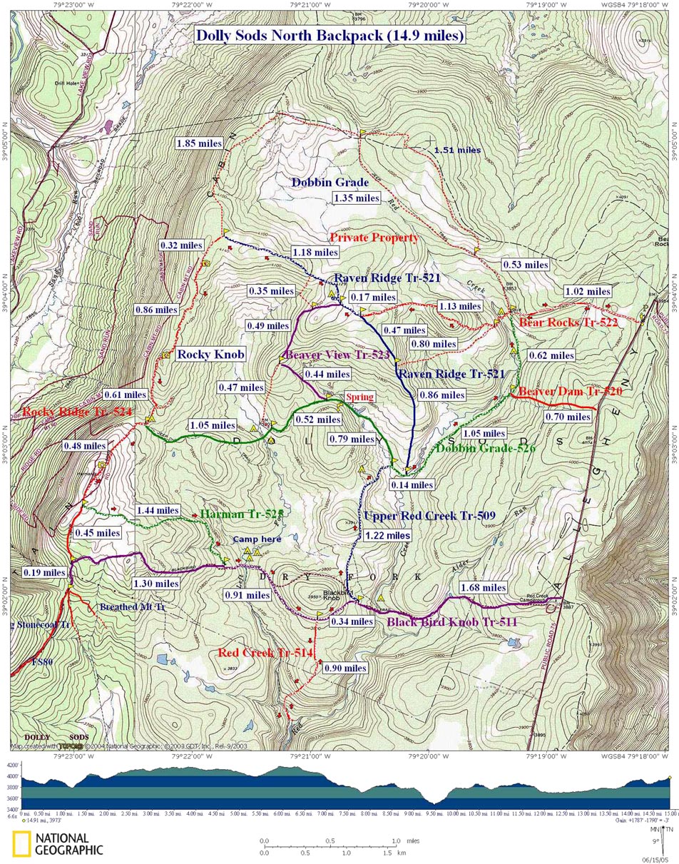
providing long-distance views and brilliant heath. For a weekend trip, try the
15-mile loop we enjoyed twice (map). The two-day, two-night loop will take you across
the high plateau, down to spruce sheltered campsites by the Red River and through
a bog. Then, you'll ascend back up to a parking lot that overlooks the whole wonderful
journey.
Park at the Bear Rocks Trailhead on the northeastern edge of the Sods. From there, head west roughly 2.2 miles before reaching an intersection with the Raven Ridge Trail. Turn right, and ascend moderately up the plateau before reaching the Rocky Ridge Trail in 1.55 miles. The Rocky Ridge Trail can be a little difficult to spot, so take care at this point.
 |
| Parking lot |
 |
| Color |
Turn right on the Rocky Ridge Trail and head south along the
ridge for about 2.35 miles until you reach an intersection with the Harman
Trail on your left. On the Harman Trail, descend increasingly quickly for 1.44
miles down to Red Creek (reached shortly after continuing left on the Blackbird
Knob Trail. Spruces blanket both banks of the creek, and form the primitive
campsite version of a luxury hotel.
 |
| Red Creek |
 |
| Welcome to the Hilton |
Next morning, force yourself to leave behind this coniferous
paradise and get back on the Blackbird Knob Trail, continuing through spruce
and hardwood forest for 1.25 miles before turning left on the Upper Red Creek
Trail and ascending, through a valley, back up the plateau. After 1.22 miles,
turn right on the Dobbin Grade Trail. By this point, you’ll have more or less
gained the plateau, but you’ll be gradually ascending the rest of your trip. Be
prepared to pick your way through bogs, and – if you’re like me – to give your
leg an impromptu mud bath. Once on the Dobbin Grade Trail, walk 1.8 miles to
return to the Bear Rocks Trail. Turn right and walk the roughly one mile back
to the parking lot.
Before concluding this post, a few useful notes:
- Look
at a map of the Dolly Sods Wilderness, and you’ll see that I’ve only been
talking about Dolly Sods North,
and that there’s a huge mesh network of trails that allows for lots of
custom routes.
- Stay
on established trails. There may still be unexploded ordnance in areas of the Sods not frequented by people. If
you see anything, don’t approach it, and report it to the Forest Service.
- Like
the rest of the Appalachians, there are plenty of black bears in Dolly Sods. If you go backpacking, hang
your food at night at least 100 feet from your tent.
 |
| Our late night ursine visitor |
No comments:
Post a Comment